Geographical reconciliation
Moderator: Forum Moderators
Forum rules
Before posting critique in this forum, you must read the following thread:
Before posting critique in this forum, you must read the following thread:

Re: Geographical reconciliation
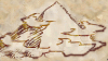
The Mountains of Gorn form a western wall for these lands. There aren't two ranges; but rather one range that the Great River runs through (unless you meant you found another map with some Mountains of Gorn).MetalKing wrote:I found there two different Mountains of Gorn.
Kallin Efinari
---Creator of "LOTE Unit Release", "7p - Afterwards", and "Chain Lightning"
(Working on 1.12 port of "7p - Afterwards")
Managing compatibility between 4000K people's ideas of what happens? Forget it!
---Creator of "LOTE Unit Release", "7p - Afterwards", and "Chain Lightning"
(Working on 1.12 port of "7p - Afterwards")
Managing compatibility between 4000K people's ideas of what happens? Forget it!
Re: Geographical reconciliation
@tr0ll: There is a .xcf version (also possibly a Photoshop one—I can't remember right now) of the mainline maps wedged into a corner of the main svn server somewhere. However, nothing I've posted in this thread is official or part of mainline. I suppose I could stuff the .xcf versions into my GitHub account if enough people were interested.

Re: Geographical reconciliation
I'm curious-what are the cities to the east of the great forest? Noct and the other one...are they from the era of strife? Also is the southern map going to be attached to create a vast mega-map(not that it isn't big already  ).
).
Last edited by Kanzil on August 19th, 2012, 1:04 pm, edited 1 time in total.
High over valleys in the red levelling rays -
In din of crowded streets, going among the years, the faces,
May I still meet my memory in so lonely a place
Between the streams and the red clouds, hearing the curlews, Hearing the horizons endure.
In din of crowded streets, going among the years, the faces,
May I still meet my memory in so lonely a place
Between the streams and the red clouds, hearing the curlews, Hearing the horizons endure.
-
Celtic_Minstrel

- Developer
- Posts: 2233
- Joined: August 3rd, 2012, 11:26 pm
- Location: Canada
- Contact:
Re: Geographical reconciliation
I was just wondering, is the xcf version of the latest huge map still available somewhere? I clicked the link on page 8, but it's been removed.
Re: Geographical reconciliation
I apologize; I'll try to reupload tomorrow.
Re: Geographical reconciliation
The resource branch of wesnoth-umc-dev might be a good home for it.
Re: Geographical reconciliation
Possibly, but I'm not sure who to talk to about getting it up there. For now, you can download the .xcf file from http://www.ziddu.com/download/20155177/ ... cf.7z.html , or the most current PNG from http://postimage.org/image/xp4wgedlx/ . I've added a few cities on and around the Emerald Plains at the request of someone working on a campaign in that area; otherwise it should be pretty much the same as the last version.
As for attaching the southern map to the main one, the only reason they're separate documents is that the main map was getting too big to work with comfortably on my old 17" CRT monitor. The two maps do fit together; there should even be a slight overlap along the edge.
As for attaching the southern map to the main one, the only reason they're separate documents is that the main map was getting too big to work with comfortably on my old 17" CRT monitor. The two maps do fit together; there should even be a slight overlap along the edge.

Re: Geographical reconciliation
I understand that Wesnoth the game has distinct forest and mountain terrains, but on a worldmap it looks pretty strange to have these distinct forests and mountains. In my opinion there is way too few forest, my understanding is that in absence of cultivation many areas would be completely covered by forests.
Also it is quite clear that this map was made by adding up different maps. E.g. in HttT the Heart Mountain is already far north with plenty of snow and wilderness, but then other campaigns instead of populating the map added two more maps north of it complete with cities etc. and there is little practical difference between them, so basically it feels as if you are playing in mainly one climate zone (there are different forests admittedly), it feels like the scale of Wesnoth is shrinking in the process. Also for my taste the map has too much freak territory (desert, mountains, swamps) as compared to agriculturally suitable land - which is the expected result if you add up campaign maps. It might not be the ideal place for a campaign, but I always wonder where do all the peasants live that make Wesnoth the largest and most important kingdom etc. In the real world landscapes (at least in Europe) and even down to individual hedgerows have a history of their own (land disputes, enclosures, jurisdictions etc.) and they are historically dense - e.g. over several hundred years you have an unlimited amount of events, wars going this way and that way, stories, narratives tied to the places. If you look at LotR the maps look very similar in style to the Wesnoth map (lot of freak territory etc.) but there is one main difference, in the Shire it presents such an amount of detail (including an individual hedgerow!) that it creates the illusion of historical density. So in my opinion if one could place some campaigns in zoomed-in versions of the main map, it would probably be better than to add map to map... I wonder why nobody considered this.
Also it is quite clear that this map was made by adding up different maps. E.g. in HttT the Heart Mountain is already far north with plenty of snow and wilderness, but then other campaigns instead of populating the map added two more maps north of it complete with cities etc. and there is little practical difference between them, so basically it feels as if you are playing in mainly one climate zone (there are different forests admittedly), it feels like the scale of Wesnoth is shrinking in the process. Also for my taste the map has too much freak territory (desert, mountains, swamps) as compared to agriculturally suitable land - which is the expected result if you add up campaign maps. It might not be the ideal place for a campaign, but I always wonder where do all the peasants live that make Wesnoth the largest and most important kingdom etc. In the real world landscapes (at least in Europe) and even down to individual hedgerows have a history of their own (land disputes, enclosures, jurisdictions etc.) and they are historically dense - e.g. over several hundred years you have an unlimited amount of events, wars going this way and that way, stories, narratives tied to the places. If you look at LotR the maps look very similar in style to the Wesnoth map (lot of freak territory etc.) but there is one main difference, in the Shire it presents such an amount of detail (including an individual hedgerow!) that it creates the illusion of historical density. So in my opinion if one could place some campaigns in zoomed-in versions of the main map, it would probably be better than to add map to map... I wonder why nobody considered this.
I am a Saurian Skirmisher: I'm a real pest, especially at night.
-
StandYourGround

- Posts: 256
- Joined: May 13th, 2009, 2:16 am
- Location: On a blue ball spinning through space at incomprehensible speed
Re: Geographical reconciliation
That doesn't really matter… this works for fantasy maps, where you get the idea that the mapmaker added only the details that where the most important.taptap wrote:I understand that Wesnoth the game has distinct forest and mountain terrains, but on a worldmap it looks pretty strange to have these distinct forests and mountains. In my opinion there is way too few forest, my understanding is that in absence of cultivation many areas would be completely covered by forests.
I will now resume lurking silently.
-
hermestrismi

- Posts: 626
- Joined: February 6th, 2016, 11:28 pm
- Location: Tunisia
- Contact:
Re: Geographical reconciliation
Any mention of Araca here?
The Dark Master, The Dark Hordes (Unofficial version), Return of the Legion , Eternal Kingdom, An Elvish Scout,Unrest in Elfland , Hidden War ...
The Dark Master Project, Arabic tra. maintainer
"But he loves you" G. Carlin
The Dark Master Project, Arabic tra. maintainer
"But he loves you" G. Carlin
-
Lord-Knightmare

- Discord Moderator
- Posts: 2365
- Joined: May 24th, 2010, 5:26 pm
- Location: Somewhere in the depths of Irdya, gathering my army to eventually destroy the known world.
- Contact:
Re: Geographical reconciliation
Not here, try this link instead: Battle for Meridia MP Era Opening Post
Creator of "War of Legends"
Creator of the Isle of Mists survival scenario.
Maintainer of Forward They Cried
User:Knyghtmare | My Medium
Creator of the Isle of Mists survival scenario.
Maintainer of Forward They Cried
User:Knyghtmare | My Medium
-
hermestrismi
- Posts: 626
- Joined: February 6th, 2016, 11:28 pm
- Location: Tunisia
- Contact:
Re: Geographical reconciliation
Thank youLord-Knightmare wrote: ↑November 4th, 2023, 3:15 amNot here, try this link instead: Battle for Meridia MP Era Opening Post
The Dark Master, The Dark Hordes (Unofficial version), Return of the Legion , Eternal Kingdom, An Elvish Scout,Unrest in Elfland , Hidden War ...
The Dark Master Project, Arabic tra. maintainer
"But he loves you" G. Carlin
The Dark Master Project, Arabic tra. maintainer
"But he loves you" G. Carlin