Geographical reconciliation
Moderator: Forum Moderators
Forum rules
Before posting critique in this forum, you must read the following thread:
Before posting critique in this forum, you must read the following thread:
-
Feufochmar

- Posts: 106
- Joined: April 27th, 2010, 9:58 pm
- Location: France
Re: Geographical reconciliation
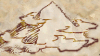
Just a remark : appart from "Meridius" and "Ocassus", the other place-names on the map are not anti-aliased.
Re: Geographical reconciliation
That's probably a compression artefact--in order to shrink the filesizes down, I've been doing an RGB->indexed conversion before posting, which is potentially lossy. All the labels were treated in the same way.
Re: Geographical reconciliation
Is there a particular piece of software you are using to make the map? If so, how can I get a copy?
Thanks,
Peet
Thanks,
Peet
-
thespaceinvader

- Retired Art Director
- Posts: 8414
- Joined: August 25th, 2007, 10:12 am
- Location: Oxford, UK
- Contact:
Re: Geographical reconciliation
Sweet, someone made a map of Meridia.
And it looks just right, more or less.
Nice job =D
EDIT: Meridian Era is basically on hold at the moment until the Khalifate are successfully added to mainline.
And it looks just right, more or less.
Nice job =D
EDIT: Meridian Era is basically on hold at the moment until the Khalifate are successfully added to mainline.
http://thespaceinvader.co.uk | http://thespaceinvader.deviantart.com
Back to work. Current projects: Catching up on commits. Picking Meridia back up. Sprite animations, many and varied.
Back to work. Current projects: Catching up on commits. Picking Meridia back up. Sprite animations, many and varied.
Re: Geographical reconciliation
@peet: I've just been using the GIMP, a general Photoshop-like image editor which can be downloaded from www.gimp.org . Other items that might be useful if you want to try making your own maps include the pack of brushes I attached to one of my earlier posts, the other brushes that live somewhere in the depths of the Wesnoth subversion repository, the parchment texture from the layered version of the original Wesnoth map (also in the repository), and either the font Monotype Corsiva, or a lookalike (I use URW Chancery, and Zapf Chancery is probably also a good match). Yes, I'm afraid that means that there is no really easy way to do this, although I created my brush set with the intention of streamlining things as much as possible. Sometimes it even works. ;P
@thespaceinvader: Glad you like it. If there are other places/names/details you would like to see added, just ask.
@thespaceinvader: Glad you like it. If there are other places/names/details you would like to see added, just ask.

Re: Geographical reconciliation
I think I know how to define what's wrong now - you mentionned you based the north of the map on the south of the main wesnoth map if I understood correctly? But that map doesn't show the most southern borders of the known lands - those are shown in The South Guard. A nice map for that sits comfy in the mainline campaign development topic but was never commited.
How about just cut the map at the neat mountainline and drop the things north of it for now?
How about just cut the map at the neat mountainline and drop the things north of it for now?
Like cats? I've made a whole faction of them to kick ass with!
Don't like cats? I've made a whole faction of them to kick their asses! So everyone's happy :)
Felinian faction is part of the Beyond Southern Hells era
kitties need sprites! art topic here
Don't like cats? I've made a whole faction of them to kick their asses! So everyone's happy :)
Felinian faction is part of the Beyond Southern Hells era
kitties need sprites! art topic here
-
thespaceinvader
- Retired Art Director
- Posts: 8414
- Joined: August 25th, 2007, 10:12 am
- Location: Oxford, UK
- Contact:
Re: Geographical reconciliation
Nothing's obiously wrong that I know of, save for the fact that i'd intended to forest to continue, albeit sparsely, right from top to bottom, through the plains. Meridius should also be in the foothills of a particularly large mountain, probably an extinct volcano.
Barossus and Orienus should probably be river-mouth ports, too, probably in the same delta.
My original idea for the map was one big river going right round the righthand side as a trade route, but I think that geologically, that simply doesn't work...
Barossus and Orienus should probably be river-mouth ports, too, probably in the same delta.
My original idea for the map was one big river going right round the righthand side as a trade route, but I think that geologically, that simply doesn't work...
http://thespaceinvader.co.uk | http://thespaceinvader.deviantart.com
Back to work. Current projects: Catching up on commits. Picking Meridia back up. Sprite animations, many and varied.
Back to work. Current projects: Catching up on commits. Picking Meridia back up. Sprite animations, many and varied.
Re: Geographical reconciliation
@StDrake: I guess that means I'm going to have to go looking for the map for tSG and see if I can incorporate it without having to start over again. If not, yeah, I can cut it a bit--no reason there couldn't be a little more desert up there.
@thespaceinvader: I should be able to fix some of that (certainly I can park a really big mountain right by Meridius, and add some bits of forest here and there--I may have to think a bit before adding another river).
Doing any of these things is going to have to wait a little while, though--right now I have an unrelated project (two of them, actually) that's eating into the timeslot I was using to work on the maps...
Re: Geographical reconciliation
the newest attempt on that map was this on the 28th page of the south guard developmen topic
I could nitpick that the heartwood label should be south of the black river. Basically going more south I'd expect a healthy block of heartwood forest covering the space between the western shoreline and leaning over kerlath hills (and mountains) to the east. Then a bit of flatland between the forests southern border and the mountain line on your map gradually turning into steppes the further east it goes, cutting into the great desert that starts probably not far east from Kerlath, so that the desert line goes like a deep ) around a kind of grassland "bay" between east of kerlath and that mountain line.
With that Meridia will get what it needs from the mountains south, and I can fit Azgars in the flatland, some plainscat settlements scattered on the steppes and probably dragons with their followers in the mountain line
I have to move my lazy bottom and draw that proposal how the north of the hill line should look like finally, but I hope I described it sufficiently enough now..
trying it with ASCII:
Spoiler:

I could nitpick that the heartwood label should be south of the black river. Basically going more south I'd expect a healthy block of heartwood forest covering the space between the western shoreline and leaning over kerlath hills (and mountains) to the east. Then a bit of flatland between the forests southern border and the mountain line on your map gradually turning into steppes the further east it goes, cutting into the great desert that starts probably not far east from Kerlath, so that the desert line goes like a deep ) around a kind of grassland "bay" between east of kerlath and that mountain line.
With that Meridia will get what it needs from the mountains south, and I can fit Azgars in the flatland, some plainscat settlements scattered on the steppes and probably dragons with their followers in the mountain line
I have to move my lazy bottom and draw that proposal how the north of the hill line should look like finally, but I hope I described it sufficiently enough now..
trying it with ASCII:
Code: Select all
~~~~ ***^^^ ...........
~~~~ ***^^^............
~~    *** ^^     ......
         steppes   ....
 Azgar                .
~~       ^^         ...
~~~~ ~^^^^^^^^  ^^^^^
Like cats? I've made a whole faction of them to kick ass with!
Don't like cats? I've made a whole faction of them to kick their asses! So everyone's happy :)
Felinian faction is part of the Beyond Southern Hells era
kitties need sprites! art topic here
Don't like cats? I've made a whole faction of them to kick their asses! So everyone's happy :)
Felinian faction is part of the Beyond Southern Hells era
kitties need sprites! art topic here

Re: Geographical reconciliation
I've been working on a southern map of my own.
Heres a couple of pics
I can't make the mountains look good next to a river. Can you give me any tips?
Heres a couple of pics
Spoiler:

Spoiler:

I can't make the mountains look good next to a river. Can you give me any tips?
Re: Geographical reconciliation
@All: Yes, still alive, and working slowly at incorporating the South Guard map into the ubermap and Southlands map. Developments will eventually be posted.
@Nagi: First off, my apologies if this comes across as a bit curt--I've had a migraine since Thursday, and it's not doing wonders for my diplomatic abilities.
You need more foothills, I think, especially around the mid-map rivers. You've got a couple of places where the terrain seems to go straight from high mountain to plain, with no transition. Also, keep in mind that water flows downhill--it isn't going to flow along the edge of a mountain range when it can gravitate toward the center of a valley.
You also need to think more about watersheds and drainage, because that river you've got ending at the lake by the forest just doesn't make topographic sense for a couple of reasons. First of all, unless you've got a really big mountain range (Rockies/Himalayas) in the way, any major water feature that near the coast is going to drain into the ocean eventually. The mountains you've drawn in just aren't enough to account for where the water's ending up. Secondly, that lake has no outlet, which means that it loses water only by evaporation, which would normally lead me to expect it to be surrounded by desert/plains/steppe/salt flats, but you've got a really big forest nearby. You can fix this by giving the lake an outlet in the form of a river that meanders southwestish to the ocean, but the rivers to the north may not be so easy to salvage. (I actually have a drainage basin overlay for the ubermap to help avoid these kinds of problems.)
Cosmetic issues: You've taken the mountains from the main map, but you're not using the same parchment background, so the colours very visibly fail to match up. If you've got the mountains on a separate layer, tweak the colour of that layer further toward yellow (or grab one of the maps from http://svn.gna.org/viewcvs/wesnoth/bran ... phy-tools/ , which should have the parchment texture that matches the mountains in the bottommost layer, and substitute that for your existing background). Also, let the source ends of your rivers taper down more--it's okay, and in fact normal and expected, if they start out only one outline-stroke-width wide.
I think that's about the limit of the advice I can manage for this evening.
Re: Geographical reconciliation
Thanks, that will help a lot.
edit. I had already redone all rivers and mountains and terrain textures when MY GIMP CRASHED. Awesome!!
edit. I had already redone all rivers and mountains and terrain textures when MY GIMP CRASHED. Awesome!!
Re: Geographical reconciliation
Save early and often--every time I fail to follow that rule, I end up regretting it (even though the GIMP is quite stable most of the time under Linux).
Re: Geographical reconciliation
Heh, it's been a while, hasn't it? I finally finished incorporating the South Guard map into the main map. Southlands/Meridia next.

Note: the full-sized image at the other end of that link is 3.5MB, so you might not want to bother if you're on a dial-up. It also has some dithering artefacts (mostly in the ocean) that were caused by an RGB -> Indexed conversion. Unfortunately, without that conversion it would be 11MB, which most image hosts just won't take. (If you're curious, the .xcf is roughly 30MB.)
Note: the full-sized image at the other end of that link is 3.5MB, so you might not want to bother if you're on a dial-up. It also has some dithering artefacts (mostly in the ocean) that were caused by an RGB -> Indexed conversion. Unfortunately, without that conversion it would be 11MB, which most image hosts just won't take. (If you're curious, the .xcf is roughly 30MB.)