Geographical reconciliation
Moderator: Forum Moderators
Forum rules
Before posting critique in this forum, you must read the following thread:
Before posting critique in this forum, you must read the following thread:
Re: Geographical reconciliation
@Mountain_King: You're welcome, and I hadn't even thought about it. I don't think it really matters much what title you give me, so long as my name is in there somewhere. Just use whatever seems appropriate.
Re: Geographical reconciliation
Heh. Just talking to myself again...
Reepurr, I have a final draft of your map. If you want changes to anything, now's the time. The biggest flaws that I can see remaining are some inconsistencies in hill/mountain/forest colour between the old Northlands map and the areas that I've added.
As a bonus, I've created some Wesnoth map GIMP brushes. These are meant to supplement rather than replace the existing brushes over in resources (which I only found the other day), and consist mostly of large swathes of things--clumps of hills, entire forests, and a complete mountain range including foothills (although I did redo three of the old brushes in an attempt at colour correction). The emphasis was on being able to draw large areas of topography quickly and make them look at least somewhat right, whereas the old brushes seem to have been made with individual details in mind.
- Attachments
-
 brushes.zip
- GIMP brushes for Wesnoth maps
- (581.35 KiB) Downloaded 344 times
-
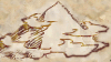
- A chunk of the northeast

Re: Geographical reconciliation
Awesome map! 
Come next update (which should be soon, given I haven't done anything for like a month), your nick will be in the credits. Unless you don't want it there of course.
I did have to make a few changes to the text though - your Monotype Corsiva (or whatever) was slightly small, I found size 16 was pretty close.
"What do you mean, "a dwarvish dragonguard with marksman is overpowered"?"
Story of a Drake Outcast | The Nonsense Era
Played HttT-Underground Channels? Thought it was rubbish? Help us develop it here!
Story of a Drake Outcast | The Nonsense Era
Played HttT-Underground Channels? Thought it was rubbish? Help us develop it here!
Re: Geographical reconciliation
Unfortunately, the Monotype Corsiva font is distributed with MS Office, which isn't common on Linux systems like mine. I've been substituting URW Chancery L, a very similar-looking GPL'd font--14-point, in this case (with a few hand-truncated risers and descenders). I think the original Northlands map uses 16-point, and the original Wesnoth map a mere 12-point, so I figured anything in that size range was probably okay. I suppose I should add "go over labels for consistent sizing" to the list of ubermap tasks. ;P
Re: Geographical reconciliation
No, I'm not dead yet, it's just that most of my effort with respect to the ubermap for the past week or so has been directed at cleaning up layer separations, making the background of the map consistent throughout, and similar boring stuff. However, I did snatch a little time to work on the southeast, and we can now see the source of the Great River (well, in broad outline, at least).
- Attachments
-
Re: Geographical reconciliation
That's one of the best-looking maps I've seen in a while. 
Here's some (mostly minor) nitpicks:
-Rivers tend to originate from mountains, given that water flows downhill and everything. Having both sides of the current river originate from (around) firecloud peak (the tallest peak locked in between Noct&Diurna, the great desert and the northern forest) would fix that.
-I'm not sure what you're intending to do with the bitter swamp and the great desert. I don't really mind as long as it's (at some point in history) nigh-impossible to get to the east from wesnoth without (a) being really good at crossing big deserts, (b) being friends with either the silver drakes (firecloud peak/silver drake mountain, and surrounding area), (c) being friends with elves (northern forest) or (d) willing to go a LONG way around, through the northern steppes or the southern lands.
-(Really minor, feel free to ignore) Rivers also tend to be natural defenses, so moving Diurna to the other side of the river it's on would help create a natural border/conflict line.
-(again, minor) Perhaps label the big forest as "Northern forest". Lintanir canonically is only the southwestern part of it.
-The floating isles are basically well-hidden floating cities above the great desert. They don't actually need to be on the map as long as it's clear that that area is a big desert.
-
dipseydoodle

- Posts: 879
- Joined: September 16th, 2008, 10:26 pm
Re: Geographical reconciliation
Part of the writing in the south-east is invisible/blurred.
Re: Geographical reconciliation
I should probably have noted: final labels are not in place in this area yet. Anything semitransparent is part of AI's original map that I haven't tackled yet, and won't appear on the final map in that form.
@AI: To take your points one-by-one:
-The problem with that is that I can't see how an inland mountain range could be generating enough water to produce something like the Great River--it needs either a honking big drainage basin or an inland sea at the far end. And having a mountain range running east-west splitting the drainage basin in that way doesn't seem right either. But at the same time, I want to keep the Great River and the Bitter Swamp in separate drainage basins... I'll try moving the hills south a bit, and the river a bit less south, so that it looks like it's running through a low area between the two land features. Maybe it dug itself a canyon?
-The northern edge of the desert near the Bitter Swamp is a bit of a mess right now. What I'm assuming is that the inland area immediately south and east of the swamp is an isolated drainage basin whose lowest elevation is in or near that swamp, with most of it also being in the rain shadow area created by the Estmark Hills. That means that what little rain manages to get into the area drains into the swamp and the small lake(s) adjacent to it (currently in need of being re-drawn). South and east of that would be desert (sand plus some salt flats). The real-world model I'm thinking of here is Lop Nur and the Taklaman Desert, in central Asia, although the Taklaman is technically a cold desert and the one to the south of Wesnoth would be a hot one. So yeah, there will be a decent-sized band of desert covering most of the area you'd labelled as the Floating Isles.
-Diurna hasn't been finalized yet, so moving it is not a problem.
-Re-examining the forest labels is already on my to-do list.

Re: Geographical reconciliation
I spotted some more or less obvious block borders that could need some stirring. Especially the ones at the top are quite disturbing. Otherwise, great work!
- Attachments
-
Re: Geographical reconciliation
Hazard of piecing the background together from several much smaller chunks. I should probably go over the whole thing again and check for lines.
-
Mountain_King

- Translator
- Posts: 569
- Joined: May 31st, 2010, 7:54 pm
Re: Geographical reconciliation
*grand appearance in puff of smoke*
Here's something I thought of that might apply to your uber-map while I was reading through the wiki:
The elves supposedly have a massive capital city named Elensia, somewhere in Lintanir forest. You might want to put it in, then again maybe not.
It's dangerous to go alone, take this!
*vanishes in puff of smoke*
Projects: Ice Age Fun, Japhel's Journey (same link), Shameless Crossover Excuse (Maintainer), and Age of Dinosaurs!
Is cothabhálach an aistriúcháin Gaeilge mé.
EXTERMINATE!!!!
Is cothabhálach an aistriúcháin Gaeilge mé.
EXTERMINATE!!!!
Re: Geographical reconciliation
<coughs and waves smoke away>
Hmmm. The question is, who's supposed to have made the map? If it was drawn by humans, they would have no idea of the exact location of Elensia.
(Also, if we want to get really silly, it's possible to imagine a setup where most of the middle of the forest is the city--giant hollow trees magically altered by the work of generations of shamans to produce housing for hundreds upon hundreds of elves . . . Seriously, though, elves building stone villages has always struck me as a bit odd. In the case of the castles, not wanting the building to be vulnerable to fire makes sense, but their homes . . . ?)
Re: Geographical reconciliation
Okay, the southeast is more complete and has labels now. Bits and pieces of particular note:
-The southernmost lake near the Bitter Marsh varies in size according to rainfall--the dotted line indicates its maximum extent if it's been really wet.
-The southern desert is now "[the] Sandy Wastes", on the grounds that a map that already has a "Great Ocean" doesn't need a "Great Desert" to go along with it.
-Many of the labels are from AI's old map, but a few of them I pulled out of my . . . ear. There are still a number of geographical features that need names.
-Yes, that really is an island in a lake in an island in a lake over near the east edge. I considered going for another iteration, but somehow I suspected I wouldn't get away with it.
The ubermap has become so large that I can't attach it even as an indexed PNG (and the .xcf is 28.2MB), so I put it on ImageShack again:


Re: Geographical reconciliation
eliddell wrote:-Yes, that really is an island in a lake in an island in a lake over near the east edge. I considered going for another iteration, but somehow I suspected I wouldn't get away with it.
If any map qualifies as an ubermap, it is definitely yours. However, it seems a bit.... empty. The western side has mountains and rivers and trees and labels galore, but the eastern side is kind of a mix of flat plains, deserts, and swamps. Also, the trees on your side are of a different color and shading than those on the mainline side. Besides that, I think it is the best attempt at a map (besides mainline one, I like it
But what is up with the Triangular Forest? It looks... out of place.
-
Mountain_King
- Translator
- Posts: 569
- Joined: May 31st, 2010, 7:54 pm
Re: Geographical reconciliation
bigkahuna wrote:But what is up with the Triangular Forest? It looks... out of place.
It's looking pretty good eliddel, other than the minor issues bigkahuna pointed out (like the trees, hills, etc). I personally like the emptiness of the southeast, it makes sense that there would be a desert so far inland.
Me thinking too much:
Oh and I see the Unstoppable Legion is on the 1.8 server. If you're interested, there's a map of a land far, far, far south of Wesnoth in it.
Mountain_King
Projects: Ice Age Fun, Japhel's Journey (same link), Shameless Crossover Excuse (Maintainer), and Age of Dinosaurs!
Is cothabhálach an aistriúcháin Gaeilge mé.
EXTERMINATE!!!!
Is cothabhálach an aistriúcháin Gaeilge mé.
EXTERMINATE!!!!