Geographical reconciliation
Moderator: Forum Moderators
Forum rules
Before posting critique in this forum, you must read the following thread:
Before posting critique in this forum, you must read the following thread:
Re: Geographical reconciliation
@Mountain_King: Nothing on the map included with your campaign on the 1.8 server was labeled, but I'm assuming that the most important area is around the marked settlement. Also, there are no mountains in the south-east corner of the map--did you mean the south-west corner, or the mountains south and eastish of the settlement?
@Simons_Mith: The name that really got me was "the Green Forest", in part because of early exposure to a kids' cartoon called "Fables of the Green Forest" that does not at all fit in with Wesnoth. Unfortunately, since someone's already working on a campaign taking place there, I doubt that it would be possible to change its name even in the extremely unlikely event my efforts were to be accepted as official.
@Reepurr: There are no volcanoes shown on the map as it stands, but when I was filling in the northeast part of the Heart Mountains I stuck a big mountain in between the tails of those two rivers, near Lintanir Forest, and there's no reason it couldn't be converted into a volcano--it isn't on any of the original maps, so it's a reasonable assumption that it hasn't been established as not volcanic. Alternatively, one could be placed either near the Great River east of the map-edge, or east of the Green Forest, in one of the hill ranges whose easternmost edges are not marked. About AI's map, see below.
@AI: I examined the "big map" from the thread you linked, and it can almost be reconciled with what I have. The problems with the north and the seacoast wouldn't be that difficult to resolve (they're just differences between the old map and the current one, anyway), but the big problem is that the Bitter Swamp from the official map appears to have somehow become part of the Great Desert. They need some kind of separator--plains, salt flats, or mountains/hills running from northeast to southwest to provide some rain shadow.
@Simons_Mith: The name that really got me was "the Green Forest", in part because of early exposure to a kids' cartoon called "Fables of the Green Forest" that does not at all fit in with Wesnoth. Unfortunately, since someone's already working on a campaign taking place there, I doubt that it would be possible to change its name even in the extremely unlikely event my efforts were to be accepted as official.
@Reepurr: There are no volcanoes shown on the map as it stands, but when I was filling in the northeast part of the Heart Mountains I stuck a big mountain in between the tails of those two rivers, near Lintanir Forest, and there's no reason it couldn't be converted into a volcano--it isn't on any of the original maps, so it's a reasonable assumption that it hasn't been established as not volcanic.
@AI: I examined the "big map" from the thread you linked, and it can almost be reconciled with what I have. The problems with the north and the seacoast wouldn't be that difficult to resolve (they're just differences between the old map and the current one, anyway), but the big problem is that the Bitter Swamp from the official map appears to have somehow become part of the Great Desert. They need some kind of separator--plains, salt flats, or mountains/hills running from northeast to southwest to provide some rain shadow.
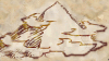
- Attachments
-
- Quick combination of the map from AI's thread with mine, 1/16th actual size
- all-wesnoth-c.png (466.84 KiB) Viewed 4941 times
-
Mountain_King

- Translator
- Posts: 569
- Joined: May 31st, 2010, 7:54 pm
Re: Geographical reconciliation
@Mountain_King: Nothing on the map included with your campaign on the 1.8 server was labeled.
Spoiler:
Last edited by Mountain_King on October 15th, 2010, 3:14 pm, edited 1 time in total.
Projects: Ice Age Fun, Japhel's Journey (same link), Shameless Crossover Excuse (Maintainer), and Age of Dinosaurs!
Is cothabhálach an aistriúcháin Gaeilge mé.
EXTERMINATE!!!!
Is cothabhálach an aistriúcháin Gaeilge mé.
EXTERMINATE!!!!
-
dipseydoodle

- Posts: 879
- Joined: September 16th, 2008, 10:26 pm
Re: Geographical reconciliation
Will this map include Azgar? This would be a great help for me.
-
Simons Mith

- Posts: 821
- Joined: January 27th, 2005, 10:46 pm
- Location: Twickenham
- Contact:
Re: Geographical reconciliation
I don't necessarily see why not. A unified map like the one you're working on would be very handy and is likely to be widely appreciated by a lot of campaign authors. The Green Forest has been changed to the Greenwood for the Fate of a Princess Campaign, primarily because I was dissatisfied with the proliferation of 'foo Forests' on the main Wesnoth map. Dorset has been unilaterally changed to Dorest too. As I was rewriting the dialogue for SkyOne's campaign, I seized the chance to make those changes. It's not like all the 'foo Forests' need to have their names changed - just changing a couple would be sufficient - but there is a cluster of not very good placenames in that part of the map. There would be minor effects on a handful of campaigns, but I don't think that's a show-stopper.eliddell wrote:@Simons_Mith: The name that really got me was "the Green Forest", in part because of early exposure to a kids' cartoon called "Fables of the Green Forest" that does not at all fit in with Wesnoth. Unfortunately, since someone's already working on a campaign taking place there, I doubt that it would be possible to change its name even in the extremely unlikely event my efforts were to be accepted as official.
Re: Geographical reconciliation
There's also a possibility of one region having different, similar or not, names depending on who, where and when was referring to it. Green Forest and Greenwood could be local names for the same forest known in different regions.
ride on shooting star
Re: Geographical reconciliation
@Mountain_King: Yes, I did have the wrong map--mea culpa. I've got the right one now (thanks for including the .xcf file in the campaign package, although I don't know if you did it intentionally). I also slotted it into the ubermap, just for the heck of it, and it looks like one of the tributaries of the Oumph River should run through the very south-west-most corner. Other than that, the coastline could use some work, the Wild Steppe needs, mmph, some hills, I think, to keep it from looking quite so bare, and the rivers could stand to be cleaned up and the easternmost one, at least, should have a tributary or two. I may also plant a forest near the eastern edge, north of the mountains. Oh, and is that little dot of blue to the immediate west of the encampment up north a lake?
@dipseydoodle: The southlands, you mean? Is there any source material available for that area at all? None of the maps I've accumulated to date goes much further south than the Aethenwood, but I haven't yet had a chance to play many of the current campaigns. If there isn't any established geography yet beyond the notes in the wiki, I can try to make something up after I'm finished integrating what I have.
@Simons Mith: Given their location, one would think that the Desert of Death and the Swamp of Desolation would have Orcish names--maybe even orcish distortions of older elven or dwarvish (saurian? mer? naga? even trollish?) names (or at least, I understand that to be how things often work in the real world). There are a lot of generic fantasyland names on the map in general, it's true. I guess my main problem is not knowing how thoroughly established many of these names really are--are they just labels on a map, or have they been used elsewhere, and are the people who used them protective of them? em3 has a good point, though.
As for officialness, I was kind of basing the likelihood of this on Midnight_Carnival's remark further back in the thread, about the devs having said they didn't want the geography set in stone. Of course, if a lot of people take this map up and use it, I suppose it could become official by default, so to speak.
(There's also the minor fact that this is becoming a pretty big map--~2200px to a side and 6.9MB as a png, and it's going to get bigger if I add in the Southlands. The size might make it inconvenient for some people to use. Hmm. Cross that bridge when I come to it, I guess.)
Re: Geographical reconciliation
That marsh is a pretty recent addition, possibly due to a misinterpretation of EI. (according to Turin, Mal-Ravanal *created* the swamp he had his HQ in, which reverted to being a desert afterwards)
And about the northern forest, ignore my outlines, it can stand to be a lot bigger. (it is said somewhere that it is huge) I said something similar in the EoS thread.
And about the northern forest, ignore my outlines, it can stand to be a lot bigger. (it is said somewhere that it is huge) I said something similar in the EoS thread.
Re: Geographical reconciliation
@AI: There may actually be a way that the Bitter Swamp could be both a desert and a marsh at different times, now that I think about it. Say that the area normally gets very little rain--it's inland and shielded by hills, so that's probably reasonable. Now, add in a shallow depression containing salt flats--a dried-up lake. Most of the time, this would be effectively desert, but if it received enough rain, it would become a (shallow, and very salty) lake again. Keep it up for long enough, seed the area with a few of the right plants (possibly with magical augmentation), and you could have a lake with some associated saltmarsh. Take the rain away again, and within a few years, the lake dries up and we're back to salt flats.
So Mal-Ravenal may just have been moving rainclouds around.
The neat thing about this theory is that it even explains why it would have been called the Bitter Swamp: the water in the area would be much saltier than seawater, effectively undrinkable.
For mapping purposes, it's a bit difficult to lay out--I guess the empty lake or lakes becomes a series of dotted lines on the map.
-
Simons Mith
- Posts: 821
- Joined: January 27th, 2005, 10:46 pm
- Location: Twickenham
- Contact:
Re: Geographical reconciliation [Placenames]
Quite agree. In fact, providing several alternative names for some places might be an interesting idea. Having orcish versions of placenames for some parts of the map, human or elven for others could add some extra detail and a bit of back story to the game with relatively little effort. I already have some ideas for some articles on racial placenames, but I have several other balls in the air as well ATM. I hope I will be able to get to this while the project is still live. There are also a couple of old forum posts of mine on the subject of placenames, including a version of english.cfg that generated a very strong scottish feel to the village names on random maps.em3 wrote:There's also a possibility of one region having different, similar or not, names depending on who, where and when was referring to it. Green Forest and Greenwood could be local names for the same forest known in different regions.
Given that most human names in Wesnoth have a bit of a Welsh feel to them, maybe I should revisit and try a Welsh-themed name set. Similarly, when the elves name things what features do they give prominence to? Similarly for dwarves, drakes, saurians etc. I have ideas on most of these, it's just the time to get them written down...

Re: Geographical reconciliation
Dwarves seem to always keep one foot in the past, so while a lot of human place names have to do with features of the land (rivers, mountains, etc.), I would expect dwarven places to have a lot of event-based names, like if a big battle happened there once.Simons Mith wrote:Similarly, when the elves name things what features do they give prominence to? Similarly for dwarves, drakes, saurians etc. I have ideas on most of these, it's just the time to get them written down...
It's spelled "definitely", not "definately". "Defiantly" is a different word entirely.
Re: Geographical reconciliation
Elves might key in to something ephemeral but recurring about a place, like the type of flower that blooms in a valley when the spring is more than usually warm, or the view from the top of a hill on the summer solstice. Alternatively, they might go in for poetic names: "the Valley of Flowers like Stars" or such. (Actually, I suppose they might do both of those things at once.)
By contrast, I'd bet that orcish placenames are distinctly unpoetic practical descriptions: I would not be at all surprised to discover that the orcs call the Swamp of Desolation "Big Mud" in orcish.
The other races are a lot harder--either they're really weird or very little has been established about them in terms of society, language, etc. I doubt ogres have much use for placenames--they'd probably designate a specific hill by pointing at it rather than naming it. Saurians might actually have a gender-segregated language yielding two names for each place.
@AI: As far as I know, entirely coincidential. Great minds think alike? ;P
@Mountain_King: I've been fiddling with your map, and I, er, may have gone a bit overboard . . . Anyway, it should be easy enough to change back anything you don't like--it's all on separate layers. Features include new coastline (similar in general outline to the original, but rather more detailed), additional water features, more forest, and I removed some roads because it quite frankly didn't make sense to have roads from the cities to random forests where no one goes unless they're being tested by elderly wizardly types. Please keep in mind that it isn't finished--even if you decide you don't want any changes, I have a lot of tweaking and cleanup to do.
- Attachments
-
- Unfinished new version of the map for Mountain_King's Ice Age campaign
-
Mountain_King
- Translator
- Posts: 569
- Joined: May 31st, 2010, 7:54 pm
Re: Geographical reconciliation
@Mountain_King: I've been fiddling with your map, and I, er, may have gone a bit overboard . . . Anyway, it should be easy enough to change back anything you don't like--it's all on separate layers. Features include new coastline (similar in general outline to the original, but rather more detailed), additional water features, more forest, and I removed some roads because it quite frankly didn't make sense to have roads from the cities to random forests where no one goes unless they're being tested by elderly wizardly types. Please keep in mind that it isn't finished--even if you decide you don't want any changes, I have a lot of tweaking and cleanup to do.
I like the the northern coast a LOT, it actually looks like it could be a real coastline now.
A couple little requests:
The small bunch of hills in the northwestern sector of the map need to be farther east, so they border entirely on the forest to the south. I was having layer troubles in GIMP when I put them so close together.
If you could fix the city lineup that could be cool too. The cities were meant to be in a perfect geometric triangle originally.
The mountainous area adjacent to the lone tower is known in the dwarf tongue as "Guthan." Might be nice to have a label there.
I also really like what you did with the water systems, a stark improvement over mine.
In short, I am impressed. Keep up the good work, and have a great day!
Best Regards,
Mountain_King
Projects: Ice Age Fun, Japhel's Journey (same link), Shameless Crossover Excuse (Maintainer), and Age of Dinosaurs!
Is cothabhálach an aistriúcháin Gaeilge mé.
EXTERMINATE!!!!
Is cothabhálach an aistriúcháin Gaeilge mé.
EXTERMINATE!!!!
Re: Geographical reconciliation
Aw, shucks.
Do you mean the little block of hills on a rough line between the Lost Woods and the encampment? (The hills west of the Lost Woods were my addition.) Either way, that should be easy enough to do.Mountain_King wrote: A couple little requests:
The small bunch of hills in the northwestern sector of the map need to be farther east, so they border entirely on the forest to the south. I was having layer troubles in GIMP when I put them so close together.
Any set of three points is technically a triangle (</math_major>), but I assume you mean you wanted a perfect equilateral triangle. As you can see from the attached image, that's going to mean moving Dobhar and Adobhar south a bit--is that okay? (I can also fix the Tri Forest to get the faux-Triforce look back--I assume that was what you were originally going for, since when I skimmed the scenario text there were a couple of Zelda references that even I could spot.) Alternatively, if you're willing to accept a slightly squatter isoceles triangle (other attachment), I could move Adobhar and Iobhar east a bit.Mountain_King wrote: If you could fix the city lineup that could be cool too. The cities were meant to be in a perfect geometric triangle originally.
I'm going to redo all the labels (making the text a point size or two larger would both make it easier to read and bring it into line with the mainline maps); adding one shouldn't be a problem.Mountain_King wrote: The mountainous area adjacent to the lone tower is known in the dwarf tongue as "Guthan." Might be nice to have a label there.
- Attachments
-
- Isoceles triangle overlaid on the city bit of the map
- tri-iso.png (298.34 KiB) Viewed 4648 times
-
- Equilateral triangle overlaid on the city bit of the map
- tri-equi.png (293.77 KiB) Viewed 4648 times
-
Mountain_King
- Translator
- Posts: 569
- Joined: May 31st, 2010, 7:54 pm
Re: Geographical reconciliation
Yes, the hills you added were the ones I was referring to (I couldn't actually remember whether I added them or not, so I just assumed that I did.  ) . Moved over just a tad to the east would fix it perfectly, as well as fix a storyline issue that I myself was having trouble with.
Equilateral triangle was exactly what I was going for (shhhh! ), so feel free to slide the cities around a tad. The people who founded the nation representative of the three cities (it's called Tir Liath if you're wondering) were very geometrically minded. So they divided the land between the original founder's three sons, giving them all a perfectly equal share. Their lands each ended at the conveniently placed Tri Forest (can be pronounced "tree" or "try", depending upon your accent.). Tri means "three" in their language, referencing the forest's three sides.
So yeah, that would be fine. I will smile now, like this.
Spoiler:
So yeah, that would be fine. I will smile now, like this.
Projects: Ice Age Fun, Japhel's Journey (same link), Shameless Crossover Excuse (Maintainer), and Age of Dinosaurs!
Is cothabhálach an aistriúcháin Gaeilge mé.
EXTERMINATE!!!!
Is cothabhálach an aistriúcháin Gaeilge mé.
EXTERMINATE!!!!